The Veterans Day parade takes over downtown streets from 1 p.m. Wednesday, Nov. 11: the route block by block. Plus I-20/59 work at McCalla and the 2026 repaving list.
Last checked Oct. 31, 2026. Refreshed weekly. Live state road information comes from ALGO Traffic, run by the Alabama Department of Transportation (ALDOT); city projects come from the Birmingham Department of Transportation.
Two agencies build and close roads in Birmingham. ALDOT runs the interstates (I-20, I-59, I-65 and I-459) and the state and U.S. routes, such as U.S. 280 and U.S. 78. The city’s Department of Transportation (BDOT) plans street projects and the yearly resurfacing program, and the Department of Public Works patches potholes.
Who to call
- Live closures, crashes and roadwork on state roads: ALGO Traffic, ALDOT’s traveler site and app
- Potholes, damaged streets, broken traffic signals, blocked storm drains: 311, or 205-254-2489, or the city’s 311 web portal
- Emergencies on the road: 911
Coming up: Veterans Day parade, Wednesday, Nov. 11
The 79th National Veterans Day Parade runs through downtown from 1 to 4:30 p.m. Wednesday, Nov. 11, rain or shine, the National Veterans Day Foundation says. The foundation’s route:
- start at 18th Street and 9th Avenue North
- south on 18th Street to 4th Avenue North
- east on 4th Avenue North to 22nd Street
- north on 22nd Street to 6th Avenue North
- west on 6th Avenue North to 19th Street
- north on 19th Street past City Hall to the finish at 10th Avenue North
Neither the foundation nor the city had published street closure times or parking rules by Oct. 31. Expect those streets to be blocked for the parade, and plan downtown trips around it. City offices and city schools are closed that day. Our Veterans Day page has the rest.
Magic City Classic, Saturday, Oct. 31
The Classic parade runs downtown from 8 a.m., from 18th Street North and 7th Avenue North to 16th Street North and 4th Avenue North, according to the Classic’s route map (PDF). The perimeter road around Legion Field closes at 9 a.m., inside a zone bounded by I-20/59, 3rd Avenue West, Center Street and Arkadelphia Road, according to the Classic’s parking and shuttle page. Kickoff is 2:30 p.m. Expect heavy traffic on I-20/59 and Arkadelphia Road after the game. Details are on our Magic City Classic page.
On the state roads now
On Oct. 30, ALGO Traffic listed no long-running ALDOT roadwork inside the Birmingham city limits. The entries in the city were crashes and abandoned or disabled vehicles on I-20/59, I-65 and I-459, and game-day traffic control on Arkadelphia Road (U.S. 78) near Legion Field.
The nearest long-running state project is west of the city on I-20/59 at Exit 104, McAshan Drive, in McCalla: ALGO lists shoulder closures on the interstate and the McAshan Drive ramps until Feb. 28, 2027. Check ALGO before you leave.
Northern Beltline. ALDOT opened the first 1.88-mile segment of the Birmingham Northern Beltline (SR-959), between SR-79 and SR-75 in northeast Jefferson County, on Tuesday, Sept. 29, the governor’s office said in its announcement. It is the first leg of a planned 52-mile I-422 from I-459 in Bessemer to I-59 in northeast Jefferson County; ALDOT is working on the next eight miles west to U.S. 31 in Gardendale and plans to award contracts on several phases in 2027.
City projects
41st Street South, Avondale. The city says construction began in May 2026 on a streetscape project along the Avondale business district. It adds bike lanes linking Avondale Park and the Hugh Kaul Trail, wider sidewalks, new pavement, high-visibility crosswalks, crosswalk beacons, intersection upgrades, more on-street parking, street lighting and rain gardens. The project page, rechecked Oct. 27, gives no finish date and lists no detours.
Birmingham Civil Rights Crossroads. A 3.16-mile network of shared-use paths, sidewalks and bike lanes on Graymont Avenue, 16th Street North and the 4th and 5th Avenue corridors, linking Graymont and Smithfield with downtown. The city says a temporary demonstration project comes first and construction begins in 2027 (project page).
Reconnecting 4th Avenue North. The city plans to return 1.4 miles of 4th Avenue North, from 9th Street North through downtown to the post office at 24th Street North, to two-way traffic. It was converted to one-way in the 1970s. The project page gives no construction date.
Rugby Avenue traffic calming, South East Lake. BDOT is adding parking-protected bike lanes, reflective bollards and a two-way cycle track on Rugby Avenue and 83rd Street. The city counted at least 83 crashes on Rugby Avenue from January 2019 to October 2024 and says the current layout is not the final one (project page).
Street resurfacing in 2026
BDOT keeps a list of the condition of every street and builds a yearly paving package from it, choosing streets by condition, location and their place in the network. The 2026 lists by council district name 127 street segments. A few examples, as listed:
- District 1: Idlewood Road from Huffman Road to Winchester Drive (Huffman)
- District 2: Montevallo Road and Oporto-Madrid Boulevard segments
- District 3: Clairmont Avenue from 38th Street South to 42nd Street South
- District 4: Norwood Boulevard from Vanderbilt Road to 15th Avenue North
- District 6: Martin Luther King Jr. Drive from Dennison Avenue to the railroad tracks
- District 8: Avenue I from 35th Street Ensley to Pike Road
- District 9: 20th Avenue North from Stouts Road to 27th Street North
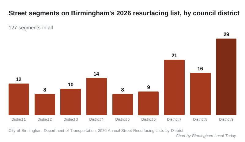
If you got a resurfacing notice, the city says the first number of the BND number on the envelope tells you which district list to search; the full number finds your segment.
Patching, resurfacing or rebuilding
The city uses three fixes. Patching, for potholes and ruts, is done by Public Works. Resurfacing lays a new surface across a whole street segment and is the city’s main maintenance tool. Reconstruction digs up and rebuilds a street whose roadbed has failed from water or soil problems.
What this means for you
- On Wednesday, Nov. 11, avoid the downtown parade route from about 1 p.m. unless you are going to watch.
- Check ALGO Traffic before a trip on I-20/59, I-65 or U.S. 280.
- Look for your street on the 2026 district lists.
- Report potholes to 311 with the exact location.
Related: getting around Birmingham, parks and trails and who to call at City Hall.
Frequently asked questions
What is the Veterans Day parade route in Birmingham?
The 79th National Veterans Day Parade starts at 1 p.m. Wednesday, Nov. 11, at 18th Street and 9th Avenue North. It goes south on 18th Street to 4th Avenue North, east to 22nd Street, north to 6th Avenue North, west to 19th Street and north on 19th Street past City Hall to 10th Avenue North.
Where can I check road closures in Birmingham?
ALGO Traffic, the Alabama Department of Transportation’s traveler information site, shows live crashes, lane closures and roadwork on interstates and state routes. City street issues go to 311 at 205-254-2489.
Is my street being repaved in Birmingham this year?
Check the city’s 2026 Annual Street Resurfacing Lists by District. If you got a resurfacing letter, the first number of the BND number on the envelope is your council district.
How do I report a pothole in Birmingham?
File a 311 request online or call 205-254-2489. The Department of Public Works handles pothole patching.
What is happening on 41st Street South in Avondale?
The city began a streetscape project in May 2026 that adds bike lanes, wider sidewalks, new pavement, high-visibility crosswalks, lighting, parking and rain gardens.
Have your say